Floodplain updated for Blue River properties
Source: McKenzieRebuilds.org
Lane County hired a technical consultant to lead the process to remove properties and areas from the FEMA floodplain maps, called a Letter of Map Revision (LOMR), in the Blue River area.
The LOMR has been approved by FEMA, effective August 26, 2022, will remove most of the Blue River community from the mapped floodplain. Most properties in the town of Blue River, as well as many properties along Blue River itself, were inside the floodplain prior to the LOMR request. (This process is in addition to the individual properties that were removed from the floodplain earlier this year through a process known as LOMA.)
Normally, property owners would need to undergo a costly process at their own expense to request that FEMA remove their property from the flood map. Lane County Land Management Division, with approval from the Board of County Commissioners, took on that effort on behalf of fire survivors in that area.
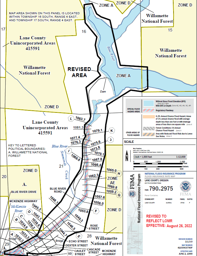
The revised area, shown below, reduces the floodplain to specific areas along Blue River and removes most of Blue River town from the floodplain.
Generally, if a property has a LOMR, the floodplain development code standards (Lane Code 16.244 ) do not apply to the property as a whole or a certain area of the property, depending on the specific LOMR approval. If you are rebuilding, considering new development, or removing or filling in material in the mapped floodplain of Blue River, you should first contact Lane County Land Management to confirm the availability of a LOMR for your property and to determine whether floodplain development standards apply. Please contact the Planner-on-Duty at 541-682-3577 or get in touch with Permit Navigator Marianne Nolte.