Situation Status Report for the Lane County Holiday Farm Fire
![]()
Lane County’s update on the Holiday Farm Fire. Issued last Friday but most info is still relevant.
1. SITUATION (Situation Update, Actions Taken)
- McKenzie River valley experienced significant wildfire events starting on 09/07/2020 at 8:17 pm starting at Holiday Farm and moving westward resulting in widespread evacuations, human life loss, structure loss, disrupted communications, and continued dangerous conditions.
- Current IAP started 10/05/2020 0800 and goes through 10/12/2020 0800. A newly formatted report (Recovery Action Plan, RAP) will be coming out Monday, October 12.
- EOC Operational hours have changed to 0800 to 1700. Battle Rhythm changed to reflect this.
- As of 10/09/2020, the fire has covered more than 174,404 acres (no new growth), is 83% contained, and has destroyed 768 structures [Source: State of Oregon Fires and Hotspots at 0808 hrs].
- Only 1 fatality is reported from this fire, and 6 injuries.
- Evacuation levels have been lifted as of 09/25/2020.
- ODOT continues to manage road hazards for highways within the perimeter.
- Lane County roads are open; Hwy 126 is open.
- Governor Brown issued a major disaster declaration, allowing for further State and County access to FEMA resources on Monday September 14, 2020.
- FEMA announced Sept. 10, 2020, federal emergency aid is available to the State of Oregon to supplement local response efforts. Expedited declaration for Public and Individual Assistance requested for Lane County, seeking a 100% federal cost share.
- President Trump signed a Federal Emergency Declaration for Oregon on Tuesday, September 15, 2020.
- Statewide there are 8 active fire events that constrain resources available to respond to this situation. Statewide, 921,840 acres have been reported burned and there have been 8 fire-related fatalities, 46 injuries, 1,354 residences and 1,316 other structures destroyed as of 0849 hrs on 10/09/2020 (There is a slight reduction in numbers due to a decrease in active fires ).[Source: Oregon Fires and Hotspots Dashboard]
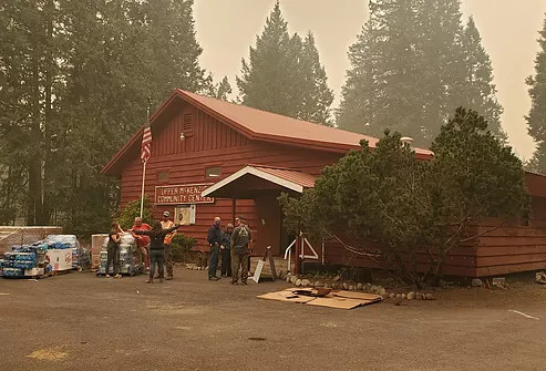
- The Multi-Agency Resource Center (MARC) reopened a mini MARC at the Lane Events running Monday through Thursday, 1pm to 4pm through the rest of the month.
- Residents can access the structural damage assessment database online. 2020.10.09 – Page 1 Highlighted portions denote changes from the previous version.
2. FIRE MAP
Fire extent as of 10/09/2020 @ 0854:
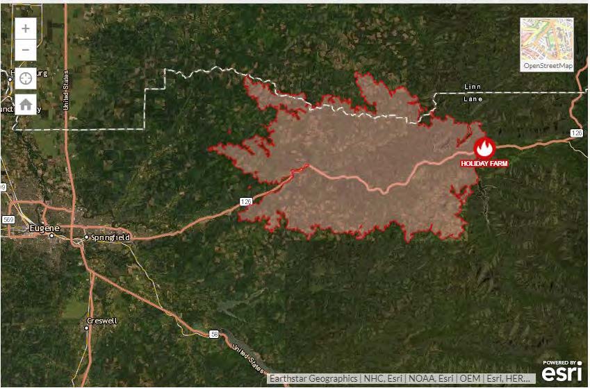
Source: https://www.oregon.gov/oem/emops/Pages/RAPTOR.aspx
Evacuation Orders: No evacuation zones as of 0855 on 10/09/2020
3: FIRE INCIDENT STATUS SUMMARY
- Current Acreage: 174,404; Containment: 83%
- Structures: Damaged = 65 Destroyed = 768
- Fatalities: 1
- Missing persons: 0
- Resources deployed: 589 personnel deployed